Uruguay's Sovereign Sustainability-Linked Bonds (SSLB)
Evolution of KPI-2: Maintenance of native forest area with respect to reference year
As part of the country's engagement for enhanced climate transparency, Uruguay's General Forestry Directorate (DGF, for its Spanish acronym) will commit to carry out a satellite-imaging mapping (cartography) of the native forest area, every four years (corresponding to the years 2021, 2025, 2029, and 2033).
The reporting of KPI-2 for those years will be conducted with a one-year lag, in line with best practices in the sector, to evaluate both the fulfillment of the 2025 target and evolution during the lifetime of the bond. It will be based on the application of remote sensing techniques, as contained in the relevant provisions of the 2006 IPCC Guidelines and the IPCC 2003 Good Practice Guidance. For the years in which the cartography is not carried out (i.e., when KPI-2 is not calculated), Uruguay (through DGF) will provide an intermediate update on any actions, policies, regulations, and/or changes in the normative framework for conserving native forest.
More information on the calculation and methodology involved can be found in the “KPI Definitions and SPT Values” section.
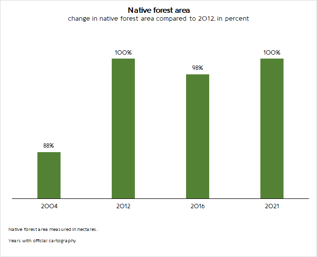
Last available value: 847,181 ha (2021)
Sustainable Performance Target 2.1: Maintain 100% of the native forest area compared to reference year 2012.
Sustainable Performance Target 2.2: Achieve a 3% increase of the native forest area compared to reference year 2012.
More information on the report and verification process of this KPI can be found in the “SSLB Annual Report” and "External Verification" sections, respectively.